This country is filled with spectacular landscapes.
Shimmering coastline, rugged peaks, furious falls, and so much more.
And the greatest way to soak it all in is along a walking trail.
We’ve rounded up some of the best hikes in Australia, with emphasis on those that can be completed as day activities.
Let’s step to it…
The state bursts with a diverse selection of visual delights, and walking tracks provide front-row access. Here are some of many highlights.
Where: Morton National Park, South Coast NSW.
Length: 5km.
Difficulty: Medium-challenging.
This is a steep trail passing interchanging landscapes with various ladders near the top to navigate. But the tradeoff – beyond a clear sense of achievement – is an almighty outlook from a dedicated viewing platform. It encompasses cliffs, gorges, coastline, and more. Well worth the effort.
Nearby accommodation: BIG4 Ingenia Holidays Lake Conjola, Tasman Holiday Parks - Myola and BIG4 Tasman – Racecourse Beach in Bawley Point.
Where: Dorrigo National Park, North Coast NSW.
Length: 4.4km return.
Difficulty: Moderate.
There must be at least one instance of waterfall chasing on this list. Inland from Coffs Harbour, the popular path slices through soaring rainforest and reveals enchanting scenes of the fast-flowing falls from front on and behind. A walk across a suspension bridge is all part of the fun.
Nearest BIG4 accommodation: BIG4 Park Beach, BIG4 Sawtell Beach and NRMA Darlington Beach in Coffs Harbour.
Where: The Rock Nature Reserve – Kengal Aboriginal Place, near Wagga Wagga.
Length: 6km return.
Difficulty: Medium-hard.
Easily accessed from Wagga Wagga, this track ascends to the peak of an attention-grabbing formation known simply as The Rock. It passes red gums and allows glimpses of native animals and bird life before the eyes are treated to wonderful panoramas of the sprawling countryside below.
Nearby accommodation: BIG4 Wagga Wagga.
Where: Yuraygir National Park, near Yamba.
Length: 10km return.
Difficulty: Medium.
Planting the feet along this coastal trail has its rewards. Following a ridge, it delivers outlooks that expose the bountiful beauty of the sparkling coastline. Spot sheltered bays, rocky reefs, and marine life, including whales in season. The views from Dirrangan Lookout are a highlight. Note: Car shuffling at Shelley Headland will halve the distance of this walk.
Nearby accommodation: BIG4 Saltwater @ Yamba.
From coastal tracks to mountain climbs, Victoria dishes up thousands of inviting paths that are supremely rich with rewards. Here is a sample of what you can expect.
Where: Mt Buffalo National Park, VIC’s High Country.
Length: 1.5km one way.
Difficulty: Medium.
You can’t have a list of the best hikes in Australia without mentioning Victoria’s ruggedly beautiful High Country region. This steep climb reaches the highest point of Mt Buffalo where jaw-dropping panoramas incorporate the mountain’s plateau and stretch across the Australian Alps.
Nearby accommodation: BIG4 Tasman - Bright, BIG4 Porepunkah or NRMA Bright.
Where: Great Otway National Park, Great Ocean Road.
Length: 1.8km loop.
Difficulty: Moderate.
Picturesque paths abound in this famous region. This track ignores the legendary coastline, instead cutting through seemingly endless rainforest before reaching elevated viewing areas that showcase the three-tiered falls from differing perspectives. Artefacts from an old timber mill add variety to this captivating path, reached roughly 50km inland from Apollo Bay.
Nearby accommodation: Bimbi Park in Cape Otway or nearby at BIG4 Apollo Bay Pisces or BIG4 Wye River.
Where: Lakes Entrance, Gippsland.
Length: 5.15km loop.
Difficulty: Intermediate.
Variable terrains feature on this centrally located circuit that leads to the ‘entrance’ of Gippsland Lakes, the inspiration for the town’s name. Wondrous water views are best admired from Flagstaff Lookout, and for added variety there is an option of returning via iconic Ninety Mile Beach.
Nearby accommodation: BIG4 Waters Edge, BIG4 Whiters Holiday Village and NRMA Eastern Beach.
What to do in Lakes Entrance? It's all here.
Where: Mornington Peninsula National Park.
Length: 6km one way.
Difficulty: Moderate.
Views of towering basalt cliffs, wild seas, farmland, and valleys all feature on a richly appealing path for the eyeballs, which begins at the Bushrangers Bay parking area. Cape Schanck and its lighthouse are other highlights as the track descends close to the peninsula’s most southern point. A walk with the wow-factor.
Nearby accommodation: BIG4 Mornington Peninsula.
Picture-perfect views are a Queensland specialty, and these pretty paths showcase a mere slither of the Sunshine State’s sparkling scenery.
Where: Carnarvon National Park.
Length: 10.8km.
Difficulty: Medium.
There are plentiful paths armed with highlights in this iconic national park. We’re circling this one, as it leads to a hefty collection of Aboriginal rock art that adds increased visual appeal to the signature sight of towering sandstone walls.
Nearby accommodation: BIG4 Breeze – Carnarvon Gorge.
Where: Near Maroochydore, Sunshine Coast.
Length: 1.6km return.
Difficulty: Medium-challenging.
Changing vegetation, rocky sections, and the chance to spot various winged species ensure there’s plenty to hold interest along this sharp climb. But it has nothing on the superb views that greet visitors at the peak of this ancient volcanic dome, which blend dazzling coastline, mesmerising hinterland, and plenty else.
Nearby accommodation: BIG4 Maroochy River, Maroochydore.
Where: Whitsunday Island, offshore from Airlie Beach.
Length: 1.3km return.
Difficulty: Moderate.
Those famed postcard-style QLD vistas await at this path’s pinnacle. A shortish ascent leads to dedicated lookouts that expose the inlet and dazzling Whitehaven Beach. Whitsunday Island is reached via ferry from Airlie Beach. Alternatively, stay in Airlie and tackle the tougher Honeyeater Lookout Trail for sweet, sweet views.
Nearby accommodation: BIG4 Adventure Whitsunday Resort and BIG4 Whitsundays Tropical Eco Resort in Airlie Beach.
With some of the most amazing scenery on the planet, the Apple Isle is ripe for hikes big, small, and everything in between.
Where: Freycinet National Park.
Length: 11km circuit.
Difficulty: Challenging.
Admire the immense beauty of Freycinet and its signature attractions from all angles on this comprehensive trail. The walk leads to Wineglass Bay Lookout – a 2.6km return track of its own – then descends to the famous white sand beach. From here, there’s an isthmus crossing to Hazards Beach before another climb that gifts views across Great Oyster Bay enroute to the car-park finish line.
Nearby accommodation: BIG4 Iluka on Freycinet, Coles Bay.
Where: Cradle Mountain–Lake St Clair National Park.
Length: 6km circuit.
Difficulty: Medium.
It’s a case of ‘pick a trail’ in these parts. The 65km-long Overland Track is the pinnacle for many, but we’re concentrating on a shorter path that’s regarded as one of Tasmania’s best walks. A starting point at wondrous Dove Lake sets the tone for the eye candy that awaits, as varying views of iconic Cradle Mountain come into play. Radiant rainforest is another feature of this top-notch trail.
Nearest BIG4 accommodation: BIG4 Ulverstone or BIG4 Stanley.
Where: Launceston.
Length: 6km return.
Difficulty: Intermediate.
This riverside track begins at landmark Kings Bridge and reveals the immense beauty of Cataract Gorge, spotted on the city’s fringes. The path winds its way to Duck Reach, one of the world’s earliest hydro-electric power stations.
Nearby accommodation: BIG4 Launceston.
Volcanic landscapes, river trails, coastal paths, and plenty else ensure SA is a dream destination for those wishing to put their best foot forward.
Where: Rosetta Head (The Bluff), Fleurieu Peninsula.
Length: 800m circuit.
Difficulty: Moderate-medium.
The stroll to this striking headland’s summit – accessible from a nearby car park – reveals spectacular panoramas that incorporate nearby Victor Harbor, Granite Island, and the peninsula’s stunning coastline.
Nearby accommodation: BIG4 Breeze – Port Elliot, BIG4 Mount Compass, BIG4 Normanville Jetty and BIG4 Cape Jervis.
Where: Overland Corner, Riverland.
Length: 2.6-2.8km.
Difficulty: Moderate.
Here, a trio of terrific trails invites footprints. Each is circuit style and ranging from 2.6-2.8km long or roughly 6km as a combined loop. Nature, heritage, and picturesque river views are all on the menu. Nearby is the circa 1856 Overland Corner Hotel – one of the state’s oldest-standing structures – which is the perfect place to unwind after a stroll.
Nearby accommodation: BIG4 parks in the Riverland.
Where: Mt Gambier, Limestone Coast.
Length: 3.6km circuit.
Difficulty: Moderate.
This path circles the city’s famous Blue Lake and delivers a wealth of differing perspectives of the natural creation. The best vistas are gleaned from Rotary Lookout. For a track that’s more demanding, follow the nearby Mt Schank to Crater Rim walk.
Nearby accommodation: BIG4 Blue Lake.
Expect a series of landscapes like no other in the NT, best revealed by following a top trail like these…
Where: Nitmiluk National Park, near Katherine.
Length: 1.8km return.
Difficulty: Moderate.
This track treats visitors to stunning outlooks of Katherine Gorge and 17 Mile Valley from a dedicated viewing platform – and all without being too taxing. The sensational scenery can be extended by tackling the Baruwei Loop Walk, which remains moderate, but is 4.8km in length.
Nearby BIG4 accommodation: BIG4 Breeze – Katherine.
Where: Litchfield National Park.
Length: 1.7km loop.
Difficulty: Moderate.
There are ample trails to follow in this treasure-packed park. This pleasant path departs from the Florence Falls picnic area and leads to a plunge pool at the base of the almighty creation. It’s an alternative to the main track that reaches the same point, although the tradeoff for likely lesser crowds on this route is the addition of 150-plus stairs.
Nearest BIG4 accommodation: BIG4 Howard Springs and BIG4 Hidden Valley in Darwin.
Where: Watarrka National Park.
Length: 6km loop (must go clockwise).
Difficulty: Medium-challenging.
This is one of the NT’s most iconic paths, beginning with a steep ascent to the top of the canyon before leading around its edges and then descending to the car park. A highlight along the way is the Garden of Eden, a striking rock hole surrounded by rare plants. If preferred, shorter walks are on offer in these parts.
Eye candy explodes throughout this epic state, and these top trails reveal just some of the splendour that awaits.
Where: Stirling Range National Park, north of Albany.
Length: 6.8km return.
Difficulty: Medium-hard.
Although Bluff Knoll’s peak is 1098m above sea level, this well-marked path is not overly daunting. In fact, it’s one of the most popular hikes in WA. Mesmerising, oft-mystical 360-degree views reward those who reach the pinnacle. Top tip: it’s recommended to have an extra layer of clothing on hand for the upper reaches of this climb.
Nearest BIG4 accommodation: BIG4 Middleton Beach and BIG4 Emu Beach in Albany.
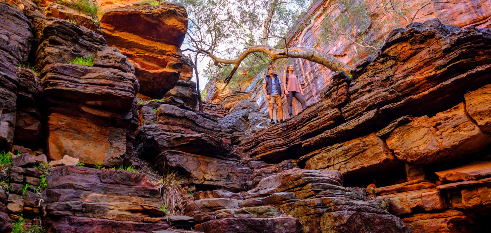
Where: Kalbarri National Park, north of Geraldton.
Length: 2.65km return.
Difficulty: Challenging.
This trail is so named for the tight bends of the Murchison River, which weaves through the park. There’s a dedicated lookout to admire the impressive sight. Or you can make things a little more challenging by following this track. Descend into the gorge and climb down ladders and over boulders to gain a whole new perspective of the jaw-dropping scenery sprinkled in these surrounds.
Nearest BIG4 accommodation: BIG4 Geraldton.
Where: Leeuwin-Naturaliste National Park, South West WA.
Length: 3.5km one way.
Difficulty: Moderate.
A small section of the iconic and epic Cape to Cape Track, this path showcases glorious coastal scenery. Featuring either bituminised or boardwalk sections surrounded by dense vegetation, the trail begins near Cape Naturaliste Lighthouse and reaches a much-photographed granite rock that juts out from the surrounding ocean.
Nearby accommodation: BIG4 Breeze – Busselton, BIG4 Bunbury Riverside, RAC Busselton Holiday Park, Mandalay Holiday Resort, BIG4 Taunton Farm Margaret River, Tasman Holiday Parks - Yallingup Beach or Tasman Holiday Parks - Yallingup Caves.
Time for a getaway? Book your stay with us now. Choose a featured park above or see all BIG4s here.
Please note: Prepare adequately when undertaking any of these walks and follow relevant signage and other guidance.