Are you looking to take a stroll in and around the charming small towns of Queenscliff and Point Lonsdale on Victoria’s magnificent Bellarine Peninsula?
Look no further! The team at BIG4 Ingenia Holidays Queenscliff Beacon knows the area well and have decided to let you in on its secret. They’ve pinpointed the best walk in Queenscliff, which takes in the likes of glorious coastal views and history-rich pockets.
This slice of Victoria makes for great exploration on two feet, so what are you waiting for? Put on your walking shoes and enjoy a path that’s paved in gold.
There are so many wonderful walks around Queenscliff and Point Lonsdale that it is hard to pick a favourite, but we’ve asked around the BIG4 Beacon Resort office for a winner. The verdict appears to be the loop that takes you from Beacon to Queenscliff and back, which includes a glorious stretch of beach. This walk is approximately 5km long and it usually takes us about an hour to complete. Your scenic walk will take you along the beach towards Queenscliff, exploring the dunes, discovering the bushland and looking out for special sites – and sights – along the way. Start your walk by exiting the BIG4 Beacon Resort entrance and heading across the Bellarine Highway to the skate park, hidden behind the large Moonah trees (a very iconic piece of Queenscliff). Stop for a quick trick or two on the quarter pipes and fun boxes if you’ve got the kids with you; or have a few hidden tricks up your own sleeve. Otherwise, you will see a dunes track to the left of the skate park, which is where your walk truly begins.
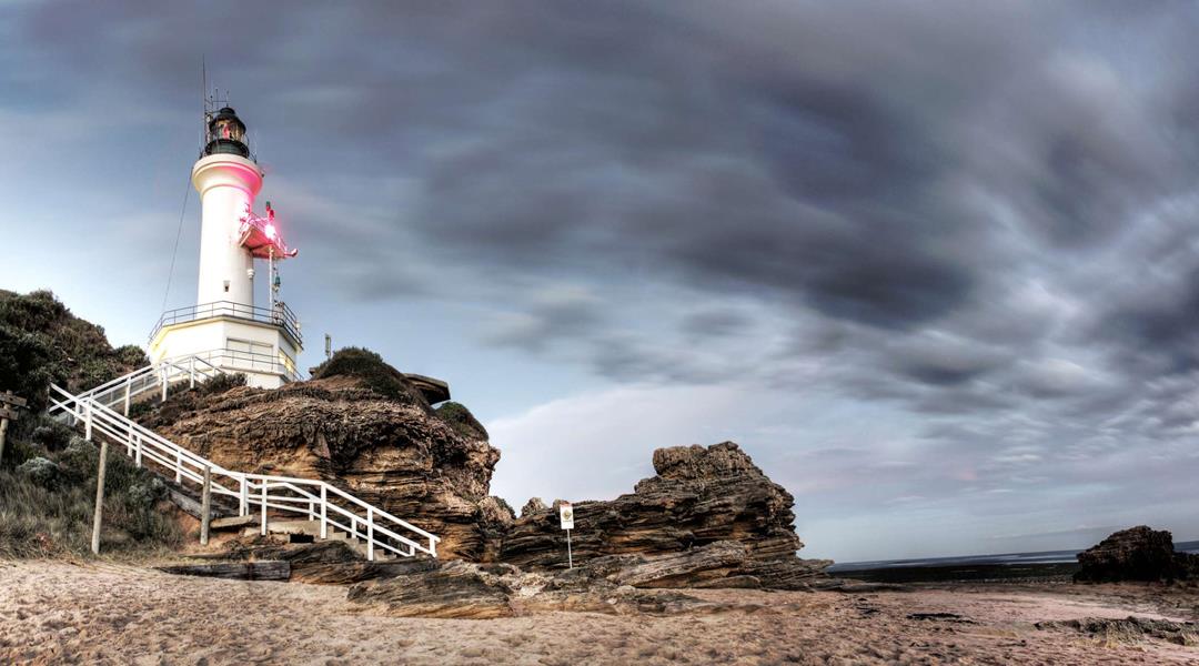
As you walk along the track towards the beach, take a look up and you will see the large triangular beacon rising out from above the trees. This beacon was built to guide boats and other seagoing vessels through the narrow channels in and out of Port Phillip Bay. It lines up with Marcus Hill, and staying between these two landmarks ensures ships avoid Corsair Rock. It is also the iconic structure that gives BIG4 Beacon Resort its name.
At the top of the dune, you will continue to go straight and head down the stairs towards the paved promenade. Turn left at the promenade and continue along the rock wall. You will notice the path finishes up and you will be continuing your walk along the sand.
Your scenic walk will take you along the beach towards Queenscliff, exploring the dunes, discovering the bushland and looking out for special sites – and sights – along the way.
Take the time to enjoy the serenity as you stroll along this quiet stretch of Narrows Beach, a bit of a hidden treasure. This beach is a designated leash-free dog beach, so you might come across some of the local dogs happily playing in the sand or running in and out of the water.
You will know that you have reached Santa Casa beach when you see the bitumen ramp up to the car park. This is also the end of the leash-free dog beach. This beach is extremely popular with families and it is patrolled during the summer by surf lifesavers. At low tide, there is an abundance of rock pools to explore. At high tide, small swells can occur, which are great for body surfing or boogie boarding.
Continue your walk up the ramp where you will see the surf lifesaving base building to your right (have a quick toilet stop here if you need – there are public toilet facilities available).
To your left you will see the dune track, which is where your walk takes you next. As you make your way through the coastal Moonah woodlands towards Point Lonsdale, you will be walking through the area known as Lonsdale Bight, or as the locals call it, ‘Lovers Walk’.
Nestled between two dunes, shielded by thick trees, and out of sight of both the road and the beach, it’s not hard to guess how this part of the track got its nickname. During the 1930s, youths would gather in this area, and around Swan Bay, to stage mock fights, hunt rabbits, go fishing, light cooking fires, and collect spent bullets.
Further along the way you will see a fort shelter and old gun emplacements. Built before World War I, they were strategically placed around Point Lonsdale and Queenscliff to protect the bay from warships passing through the heads.
As you near the end of the dune track, you will come across a beautiful lookout point with panoramic views of the beach, towards both Point Lonsdale and Queenscliff.
From here, you will be able to see Point Lonsdale Lighthouse and Rip View Lookout to the right. Directly opposite you will see Point Nepean – a national park featuring 19th century fortifications and a quarantine station, forming the southern point of Port Phillip Heads.
Between Point Nepean and Point Lonsdale is a body of treacherous water known as ‘The Rip’. Look out for the little orange pilot boats whose highly skilled captains climb aboard the larger ships and drive them through the narrow gap of water in and out of Port Phillip Bay.
You are nearing the end of you walk when you reach an intersection. If you go left, you will be back on the beach promenade (go ahead, continue to Point Lonsdale – it’s our second favourite walk!) and if you go right, you will continue to a car park that you will walk through until you get to the walking track which takes you back home, to BIG4 Ingenia Holidays Queenscliff Beacon.
We think it’s an hour well spent and one of the best ways to truly take in the beautiful surrounds of Queenscliff and Point Lonsdale.
Isn’t it time you enjoyed a brilliant break? Book your next BIG4 getaway now.